Parkes Holography
M. Kesteven, G. Graves & M. Calabretta
- Summary
- Introduction
- 3.95 GHz holography
- 12.75 GHz holography
- Analysis and Discussion
- Recommendations
- Appendix A
Summary
A holographic survey of the Parkes 64m antenna was made on June 29, 1996, at a frequency of 3.95 GHz.
Surveys at 12.75 GHz were succesfully completed on July 18/19, 1996.
Both surveys indicate that the focus cabin upgrade has left the surface slightly deformed; an adjustment strategy is outlined.
Introduction
Previous holography surveys of the 64m antenna, at 12 GHz (1988, RPP3401) and at 4 GHz (Oct. 1995, AT/40.3/175) had shown that the surface adjustments made by D.Yabsley in 1965 had achieved an excellent figure. The adjustments aimed to keep the surface as close as possible to the nominal parabolic shape at all elevations. A low rms surface error was observed in the holography surveys at elevations of 43 and 51 degrees.
The present holography campaign was designed to measure the changes to the antenna which followed the installation of the new focus cabin in December 1995. The October 1995 survey thus serves as benchmark.
The 3.95 GHz Survey
The procedures followed were those adopted in October: we observed Intelsat VII at 174 degrees longitude (with ephemerides kindly provided by the Intelsat operations). The satellite is at an elevation of 43 degrees. We followed a 129x129 raster centred on the satellite boresight, scanning in elevation at 129 seconds/scan. We returned to boresight for a calibration after every scan.
Appendix A lists a number of technical problems that were encountered. These may lower slightly the quality of the image, but they do not affect the main conclusions.
Figure 1 shows the 129x129 surface map. Figure 2 shows the corresponding pre-upgrade map, and the difference map is shown in figure 3. The additional load of the new focus cabin seems to have had only a modest impact on the surface - the post-upgrade image is not very different from the pre-upgrade image; the depressed region around the lift-leg has increased in area and depth, but the rest of the surface seems unaffected.
The boresight signal-to-noise was about 65 dB which leads to a surface rms (measurement) error of 0.5mm. The periodic structure in the outer section of the dish (22m to 32 m radius) is due to the fact that the mesh panels do not conform exactly to the overall paraboloid. The high ridges are located above the ribs.
Table 1 summarises the results from the processing of the data, for both the October, 1995 and the June, 1996 surveys.
| October 1995 | June 1996 | |
|---|---|---|
| E-W focal plane error | -5 (1) mm | -4 (1)mm |
| N-S focal plane error | -10 (1)mm | -10 (1)mm |
| Axial focus error | 4.6 (0.2)mm | 4.3 (0.2)mm |
| Az pointing error | 1.9 amin | 0.0 amin |
| El pointing error | -1.4 amin | 1.3 amin |
| Half-path rms error | 2.1mm | 2.5mm |
| Estimated gain | 67.2 dB | 66.5 dB |
| Nominal gain | 68.5 dB | 68.5 dB |
The 12.75 GHz survey
A set of 12.75 GHz images were obtained during the nights of July 18 and 19. The target satellite was Optus B3, at an elevation of 50.7 degrees.The 129x129 images obtained are identical - their details are given in Table 2. The aperture illumination function is shown in figure 4, and the surface deviation map is in figure 5. The surface map shows just the inner 44m (the perforated panels) as the mesh area is too confused to image at this frequency.
| July 18 | July 19 | |
|---|---|---|
| E-W focal plane error | -6mm | -12 (0.8)mm |
| N-S focal plane error | -16mm | -15 (0.8)mm |
| Axial focus error | 2mm | 1.0 (0.1)mm |
| Az pointing error | 0.4 amin | 0.5 amin |
| El pointing error | -1.2 amin | -1.4 amin |
| Half-path rms error | 0.86mm | 0.86mm |
| Estimated gain | 73.5 dB | 73.6 dB |
| Nominal gain | 75.3 dB | 75.3 dB |
Each pixel in these images is the average over an area of 55x55cm. The surface deviation map shows the difference between the actual surface and the nominal paraboloid; the error in the deviations is 0.1mm.
Analysis and Discussion
The interpretation of the holography data requires some care, since we have just two snapshots (at elevations 43 and 53 degrees) in a complex structural problem.
It will be helpful to summarise here some background:
A. The survey work of 1964-1966 (Yabsley et al) showed how the antenna deformed with elevation.
B. The surface was adjusted in 1966 according to D.Yabsley's prescription. The guiding principle was to minimise, for each point on the surface, its excursion relative to a nominal paraboloid rigidly attached to the vertex. That is, the principle was to minimise the extrema, rather than to form a perfect paraboloid at some specific elevation.
Fig. 6 , Fig. 7 , Fig. 8 , Fig. 9 and Fig. 10 are based on the original survey data and show the surface at different elevations. The views are from the location of the Best Fit Focus.
C. The focus cabin was upgraded in 1995, doubling the weight of the cabin. The ribs which support the tripod legs were strengthened.
Is there any evidence of localised damage to the surface?
EDE appear to have been successful in protecting the surface of the antenna. In spite of the various engineering operations involved in the upgrade there is only one damaged panel visible in the 12.75 GHz survey (at the edge of the solid surface, under the lift leg); otherwise the surface seems OK.
How would the structural changes show up?
The main result of the upgrade is an increase in the tripod leg loading on the surface, and a consequent increase in the local deformation of the surface. (The pre-upgrade data, fig. 6 and fig. 10 , for example, show that the tripod legs impose quite distinct localised deformations). However, the visibility of the deformations will vary with elevation. At elevations around 45 degrees the upper tripod legs change from tension to compression, and our difference map, an at elevation of 43 degrees, should therefore be neutral around the upper tripod legs. fig. 6 and fig. 7 show that the deformation around the lift leg is at an extremum at 50 degrees elevation.
Our difference map is broadly consistent with this argument: we see few (none ?) deformations around the upper tripod legs, but significant depression at the base of the lift leg.
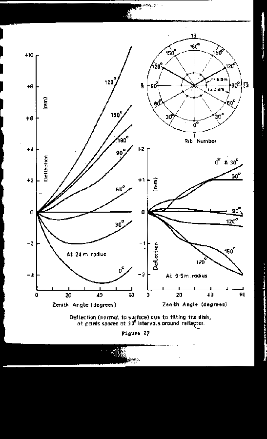
Readjustment Strategy
Figure 27 of D.Yabsley's report helps focus the discussion:
The surface deflection around the upper tripod leg increases monotonically as the antenna tips from the zenith to the horizon; after adjustment, the surface was biassed to have zero deflection at mid-elevation. The upgrade increased the loading, and thus the deflections; however, the excursions will no longer be symmetrical since the neutral point (elevation 45) is not the mid-range used in the original adjustments. All this argues for no adjustment to the upper area - the surface already looks pretty uniform at an elevation representative of most observations, and any shift in symmetry is in a favourable direction (lower elevations). There are a number of panels in the upper area which could benefit from an adjustment, since these are probably localised defects, unrelated to the large scale structural deformations.
The loading at the base of the lift leg is always in the same direction, so the additional burden of the upgrade increases the deformation at all elevations; since elevation 53 degrees (the holography elevation) is close to the elevation of maximum deformation, the adjustment should stop short of achieving a perfect paraboloid.
Do we understand the 22.5 GHz data?
John Reynolds () has reported results which show that the 22.5 GHz antenna efficiency has dropped subsequent to the upgrade. The gain curve observed (with Best Fit Paraboloid tracking enabled) is shown in figure 12. The data present two problems: the peak efficiency is low (down 25% from the pre-upgrade value), and the efficiency changes with elevation faster than the Yabsley data would suggest. .
The variation with elevation is presumably due to the large scale deformations of the antenna; Table 3 summarises these values derived from the Yabsley et al survey data, expressed as rms measured over the inner 44 m. If we attribute the bulk of the rms to the local deformations around the tripod legs, then we could expect a rough doubling of these values after the upgrade.
| Elevation | Pre-upgrade rms | Total Post-upgrade rms |
|---|---|---|
| (degrees) | (mm) | (mm) |
| 90 | 0.53 | 1.3 |
| 80 | 0.38 | 1.1 |
| 70 | 0.26 | 0.9 |
| 50 | 0.24 | 0.9 |
| 30 | 0.45 | 1.2 |
The third column in Table 3 has an estimate of the effective rms at different elevations; it is obtained from the holography measured rms (0.9mm) at elevation 50, combined with large scale rms of column 2 (doubled). The implied small scale rms of the surface is 0.75mm. Since the values of column 3 would require a very steep gain/elevation function the estimates are clearly pessimistic.
The surface error maps of the holography survey are averages over a 50x50cm area; surface roughness on a finer scale than this would be lost in these maps, although it would have an impact on the efficiency. Fortunately, the amplitude maps do provide a guide to the fine scale roughness. Figure 13 shows the radial profile for the 12.75 GHz data (averaged from figure 4); also shown is the feed profile. The match is excellent, which indicates that there is no significant difference between the solid and the perforated panels. The argument is this: the observed amplitude will fall, even if the surface is perfectly reflecting, if there are significant phase variations over the pixel area. We see an example of this at the boundary between the solid and the perforated panels (at a radius of 8.5m); a plate was installed to bridge the gap between these two surfaces. The plate is about 20 cm wide, and is 3mm thick, sitting on top of both surfaces, and this will cause the amplitude to drop of about 1 dB. The final step in the argument is to argue that the solid panels have a small scale rms which is modest. The data do not provide an explanation for the overall drop in efficiency; they do provide a possible explanation for the gain/elevation function. Adjusting the surface according to the 12.75 GHz holography should improve the efficiency, but by just a modest amount (10% perhaps).
Recommendations
- We should raise the mesh panels near the lift leg, following the 3.95 GHz holography guidance; the panels should be brought close to the mean plane, but left a small amount below (say 1mm).
- We should adjust the perforated panels following the 12.75 GHz holography data. The principle should be to obtain as uniform a surface as possible over the bulk of the antenna, leaving the secors adjacent to the lift leg perhaps 0.5mm low.
Appendix A
Technical problems encountered during the surveys
- The 3.95 GHz receivers were modified after the October run, in order to simplify the LO conversion chain. The modifications required some further work, reducing the RF gain. Once this was done the receivers worked well.
- The control system (Bunyip) has taken a turn for the worse, and no longer operates as reliably as it did last year: the UT indication of a scan start is unreliable at the one-second level. The post-hoc data repair was painful, but seems to have been successful: the three separate surveys, at different resolutions, all show the same gross features; in addition, there are a number of fine scale features which we know to be present (eg, the hatch covers near the vertex) and which are visible in the high resolution image.
The data collection software has now been modified to ensure that this problem will not recur.
- The boresight phase data (the calibration data) for both the 3.95 and the 12.75 GHz surveys showed periodic excursions. It was suggested that the airconditioner in the focus cabin was responsible - when active it would drop cold air onto the receiver and synthesiser. The airconditioner was disabled for the last 12.75 GHz survey, and the calibration data was significantly cleaner.