Thermal Emission from Jupiter
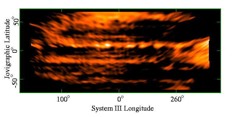
The image above is a radio `map' of Jupiter at 2cm, derived from VLA observations taken on 25 January 1996. The data were taken by Imke de Pater (UC Berkeley), and were further reduced and imaged by Chermelle Engel (University of Melbourne) and Bob Sault (ATNF).
Due to the fast rotation period of Jupiter (approximately 10 hours), radio observations are rotationally smeared. Radio images are generally longitude-averaged with only low resolution maps produced. This has resulted in longitude dependant features of Jupiter remaining unobserved in radio wavelengths. In this project we produced a 2cm longitude/latitude map of Jupiter using 6 hrs of data taken by Imke de Pater.
In order to produce a longitude/latitude map of Jupiter, we had to take into account:
- The rotation of the Jupiter throughout the observation.
- The inclination of the orbit.
We produced the map by imaging many small regions of Jupiter and combining them together. Each region had a central longitude and latitude. To image each region, we have performed a number of operations on each visibility:
- We subtracted the contribution expected for an oblate spheroid of the appropriate size and distance of Jupiter. A brightness temperature of 150K, with limb darkening was assumed.
- Each visibility record was shifted by the displacement required to put the specific longitude,latitude pair at the centre of our image.
- We accounted for the change in geometry and sensitivity when seeing a region in projection at different places on the Jovian surface. This amounts to an operation on the u-v coordinate on a visibility, as well as a scaling of the visibility amplitude.
To understand the geometry that needs to be accounted for, consider the following diagram. A cross, as seen by an observer, will appear different depending on the viewing geometry. If the cross is off the equator, it will appear fore-shortened, and as the planet rotates, the cross will become distorted.
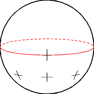
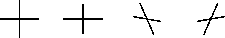
The changes in size and distortions are easily seen if the crosses in the above are placed side-by-side:
The image of a region was formed from these modified visibilities. Because the operations on a visibility are valid in a `small angle' sense only, many images of small regions need to be formed (we are approximating the spheroid by a facetted surface). Finally we brought together all the regions from -150,150 degrees longitude and -60,60 latitude together to form this map.
An visualisation of the resultant map have been produced by Paul Bourke and Matthew Bailes (Swinburne University of Technology). They have also produced some stills.